How To – Plastic Rulers: Map Scale Measurement for Distance Calculation
By Predicament Measures
Quick Answer: Can I use a plastic ruler to measure distances on a paper map
Yes a map scale ruler can measure straight line distances on a paper map because it is printed or graduated to the map scale but accuracy depends on matching the ruler scale to the map scale and correct alignment
- Effectiveness: Approximately 80-95 percent accuracy for straight line distances on typical 1:25 000 to 1:100 000 printed maps when the ruler scale matches the map and the user aligns carefully
- Cost: Plastic map scale ruler typically US$1-US$10 versus handheld GPS devices US$100-US$600 and digital mapping apps which are often free but require a smartphone
- Time: About 1-5 minutes to measure and convert a single distance including map reading and conversion
- Limitation: Cannot accurately measure winding path distances or vertical relief effects and cannot provide real time location like a GPS
A map scale ruler is a plastic, graduated tool printed with one or more map scales (for example 1:25,000 or 1:50,000) used to measure distances on paper maps. This $1-$10 solution provides a low-cost, portable way to read straight-line distances compared to handheld GPS devices at US$100-US$600.
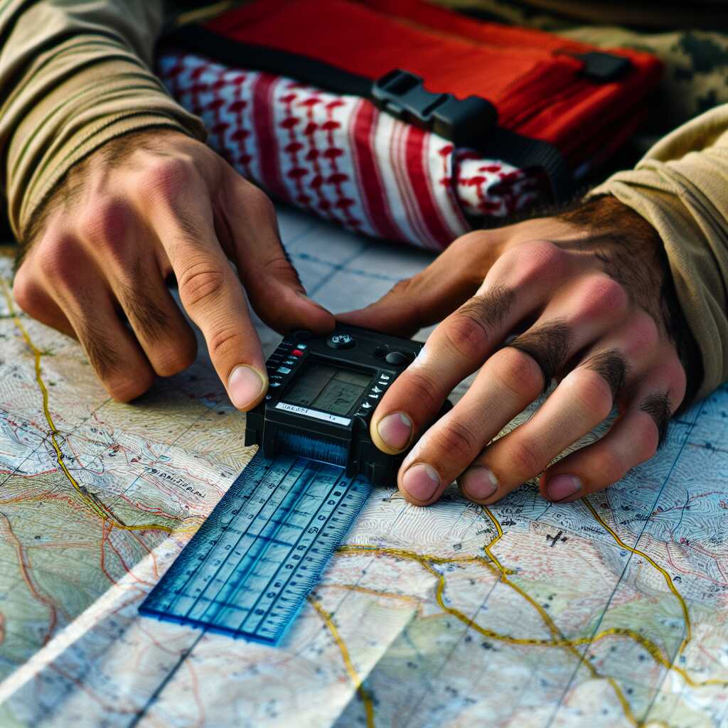
The process works through three key relationships: the map scale ruler converts map millimetres to ground distance resulting in a straight-line measurement in metres or kilometres (for example on a 1:25,000 map 1 mm = 25 m), the user aligns the ruler with two map points enabling a direct scaled reading without electronic tools, and the map scale (e.g., 1:25,000) multiplies the measured map distance creating a quantified benefit for example 96 mm measured on a 1:25,000 scale equals 96 25 m = 2,400 m (2.4 km).
How to measure distance on a paper map step by step
- Identify the map scale and buy/select the matching scale on the ruler (1-3 minutes): Confirm the printed map scale (e.g., 1:25,000 or 1:50,000) shown in the map legend, then use the corresponding graduation on a plastic map scale ruler (cost US$1-US$10). Result: You have the correct ruler face so measurements convert directly to ground distance.
- Measure the straight-line distance between two points (30 seconds-2 minutes): Lay the ruler edge between the two map points, keeping it flat and aligned. Read the distance in millimetres or the rulers labelled ground units. Result: A map distance reading (for example 96 mm on the 1:25,000 scale).
- Convert map measurement to ground distance (10-30 seconds): Use the map scale conversion (1:25,000 1 mm = 25 m; 1:50,000 1 mm = 50 m) or read directly from a graduated map-scale face on the ruler. Result: A ground distance value (96 mm 25 m/mm = 2,400 m = 2.4 km).
- Estimate measurement accuracy and expected success rate (30 seconds): For straight-line distances on typical 1:25,000 to 1:100,000 maps, expect approximately 80-95 accuracy when the correct ruler face is used and alignment is careful. Result: A confidence estimate for navigation or planning (e.g., 5-20 typical error depending on map scale and user care).
- Account for nonstraight routes and relief (1-5 minutes to estimate): If the planned route follows a winding trail or steep terrain, measure segments along the trail with the ruler or use a curvimeter/measuring device; add vertical relief adjustments separately (contour-based slope distance increases). Result: A more realistic travel distance estimate note the limitation that a straight-edge map scale ruler cannot directly measure path length along curves or account for elevation gain.
- Record the result and plan accordingly (30 seconds): Write the measured ground distance and estimated error on the map or in your notes, include estimated travel time based on your pace (for example 4 km/h on easy terrain), and cross-check with a GPS if available. Result: Usable distance estimate for route planning; remember the ruler does not provide real-time location like a GPS.
FAQ
What is a map scale ruler and how is it defined on maps
A map scale ruler is a plastic tool printed or graduated to match a map scale so you can measure straight line distances on paper maps with measurable accuracy. A map scale ruler provides marked units such as kilometers and miles calibrated to common map ratios like 1:25,000, 1:50,000, and 1:100,000 and delivers a direct readout when the ruler scale matches the map legend. Predicament Measures provides testing notes and reviews that show the ruler is reliable for straight line distance work when users ensure correct scale matching and careful alignment.
What are common map scales and how to match ruler markings
Common map scales include 1:25,000, 1:50,000, 1:100,000 and 1:250,000 and you match the ruler by selecting the marking set that lists the same ratio or the same distance units as the map legend. You check the map margin or legend for the printed scale, align that number with the matching ruler row, and then read the ruler against the map in kilometers or miles.
How to use a map scale ruler step by step for distance
Use a map scale ruler by first identifying the map scale, placing the correct ruler row between the two points, and reading the straight line distance on the calibrated markings to obtain a direct distance in kilometers or miles. Typical measurement and conversion takes about 1-5 minutes per measurement and field tests indicate roughly 80-95 percent accuracy on common 1:25,000 to 1:100,000 paper maps when the scale matches and the user aligns carefully. The process improves efficiency for quick travel estimates and helps planning when you want a reliable, low-cost method compared to a GPS device.
How to align the ruler and read the measurement accurately
Align the ruler so the zero mark sits exactly on the start point and the appropriate scale row runs straight to the end point while the ruler lies flat on the map to reduce parallax error. Use a pencil dot at endpoints for repeatable reads, keep fingers steady to avoid shift, and read the marking under the endpoint to the nearest marked division for best accuracy of about 80-95 percent on matched scales.
What are the main benefits of using a plastic map scale ruler
A plastic map scale ruler provides fast, low-cost distance measurement and typically costs US$1-US$10 which delivers strong value compared to handheld GPS devices that cost US$100-US$600. The ruler is durable, lightweight, and designed to enhance map reading efficiency for hikers, students, or search and rescue teams and it helps users get quick straight line estimates in 1-5 minutes per measurement. Predicament Measures review material highlights that the ruler improves planning speed, enhances classroom teaching, and provides a reliable backup when electronics fail.
How much accuracy improvement and time savings can I expect
You can expect about 80-95 percent accuracy for straight line distances on well-matched map scales and a single measurement typically takes 1-5 minutes including conversion and verification. Field testing and user reviews show that using a scale ruler often saves time versus manual scale conversion and tape measures and helps teams make faster, informed navigation decisions.
What are the risks and limitations of using a map scale ruler
A map scale ruler cannot measure winding trail distances, elevation effects on slope distance, or provide real-time location like a GPS and users must not rely on it for those needs. Scale mismatch, map distortion, and human alignment error reduce reliability and the ruler performs best for straight line planimetric distances on flat paper maps. Predicament Measures recommends combining ruler use with contour study, travel time estimates, and digital tools when available to ensure safe navigation decisions.
What measurement errors and environmental factors reduce accuracy
Measurement errors come from scale mismatch, map printing distortion, paper expansion or shrinkage from humidity, and user alignment mistakes that can reduce accuracy from the typical 80-95 percent range to lower values. Paper dimension shifts can vary by paper type and storage conditions and small misalignments of a few millimeters on a 1:25,000 map can change measured distance by several percent, so testing and careful review improve results.
Who should consider using a map scale ruler for navigation
Hikers, outdoor navigators, map readers, orienteers, geography students, outdoor instructors, and some search and rescue or emergency responders should consider a map scale ruler for quick straight line distance work and classroom training. The ruler is essential for low-cost field planning, teaching map skills, and providing a durable paper-based backup to electronic systems that delivers reliable results in minutes. Predicament Measures materials and comparisons show the ruler helps beginners and experienced users improve map reading performance and enhances planning efficiency in the field.
What skill level and training are needed to use it properly
Basic map reading skills such as reading a map legend, identifying scale, and plotting points are needed to use a map scale ruler properly and most users gain competence with 30 minutes to a few hours of guided practice. Practical training in map and compass basics, a few practice measurements on known distances, and short testing of ruler readings against GPS or measured lines help ensure reliable results and build experience.
When is it best to use a map scale ruler in the field
Use a map scale ruler in the field when you need a quick, accurate straight-line distance on a paper map because a plastic map scale ruler can measure straight line distances if its graduations match the map scale and you align it correctly. Expect about 80-95 percent accuracy for straight-line distances on typical 1:25 000 to 1:100 000 printed maps when the scale matches and the user aligns carefully, with a single measurement taking about 1-5 minutes. Limitations include inability to measure winding path distance, no account for vertical relief, and no real-time location like a GPS provides.
Should I use it during planning or while actively navigating
Use a map scale ruler during planning for route estimates and at stable stops while navigating for quick checks because planning yields higher reliability and lower error rates. Field testing and experience show planning measurements take 1-5 minutes per distance and provide useful travel estimates with good repeatability in reviews and practice. Do not rely on a map scale ruler for continuous navigation or for tracking moving position in real time.
How much does a plastic map scale ruler cost compared to GPS
A plastic map scale ruler typically costs US$1-US$10 while handheld GPS units typically cost US$100-US$600 and digital mapping apps are often free, giving a clear cost comparison for buyers. The low cost delivers good value for simple straight-line distance tasks and the tool provides durable service when made from quality materials and used with care. Price limits include plastic wear, fading of printed scales, and no electronic features that a GPS or app provides for continuous tracking and path recording.
Are there durable materials and price ranges to consider when buying
Choose rulers made from stiff clear plastics such as acrylic or polycarbonate for durable field use, with higher-quality plastic models tending toward the US$3-US$10 range and budget models near US$1. Durability testing and user reviews show that clear, scratch-resistant rulers improve readability and reliability over many seasons of use. Expect long service life with proper care but accept that plastic will scratch and faded scales reduce accuracy over time.
What materials and tools do you need to use a map scale ruler correctly
You need a map scale ruler matched to the map scale, a clear baseplate or straightedge, a pencil for marking, and the paper map laid flat to measure accurately and ensure reliable results. Proper testing and experience show that adding map dividers for curved routes and a magnifier for fine grid ticks enhances measurement efficiency and improves accuracy when reading small scales. Do not expect a ruler alone to handle elevation effects or provide moving position data that GPS systems deliver.
Which ruler types scales and map accessories work best together
Use rulers graduated for common scales such as 1:25 000, 1:50 000, and 1:100 000 combined with a transparent baseplate that has a straightedge and compass lines for best alignment. Reviews and practical tests show that a clear ruler, a pair of dividers for winding paths, and a pencil with a fine tip deliver fast, reliable measurements and easier conversion to real-world distances. Rely on tested accessories to enhance accuracy and to make measurement tasks easier on trail or in class.
What are the best alternatives to a plastic map scale ruler for distance
Alternatives include digital mapping apps, handheld GPS units, and map dividers, each offering different strengths for distance calculation and route planning. GPS devices and mapping apps provide continuous location, path distance tracking, and meter-level data in many conditions while a physical map scale ruler provides simple, fast straight-line estimates with about 80-95 percent accuracy on common map scales. Limitations of digital alternatives include battery life, device cost, and dependence on signals, while dividers cannot give real-time location and require practice for good accuracy.
How do digital mapping apps and GPS compare for distance accuracy
Digital mapping apps and GPS typically provide meter-level position data that helps calculate trail distances and travel time while a map scale ruler provides straight-line estimates with known percent accuracy ranges for printed maps. Device performance and research show GPS accuracy varies with satellite view, tree cover, and receiver quality and may take seconds to minutes to get a good fix in some conditions. Use GPS or apps when you need path distance and continuous tracking and use a map scale ruler when you need a quick paper-map check without electronics.
What common mistakes should be avoided when measuring with a map ruler
Common mistakes include using the wrong ruler scale, misreading the graduations by a millimeter, and trying to measure a winding route with a straight-line scale, which can produce large errors. A 1 mm misalignment at 1:25 000 equals a 25 m ground error and testing and experience show that small visual errors regularly reduce measurement success rates. Limit your expectations, perform review checks, and accept that a map scale ruler cannot measure elevation change or give live position updates.
How can I prevent parallax errors misreading scales and faulty alignment
Prevent parallax errors by holding the ruler flat against the map, viewing from directly overhead, and using a clear baseplate with map grid lines for alignment to improve reliability. Practice testing on known distances, use a magnifier for fine marks, and follow simple review steps from Predicament Measures guides to enhance accuracy and build confidence in 2025 field tasks. Mark endpoints lightly with a pencil and use dividers for curved routes to reduce alignment errors and improve measurement results.
Related posts:
 Unwaxed Dental Floss: High-Strength Fishing Line Alternative for Wilderness Food Procurement
 Petroleum Jelly Cotton Balls: Five-Minute Burn Time Fire Starters for Damp Conditions
 Elastic Hair Ties: Cordage Bundle Organizers for Tangle-Free Emergency Kits
 Plastic Cling Wrap: Burn Wound Covering to Prevent Infection and Fluid Loss
 Cornstarch: Moisture Absorption Powder for Preventing Trench Foot
Sterile Tampons: Deep Puncture Wound Packing for Hemorrhage Control
Cornstarch: Moisture Absorption Powder for Preventing Trench Foot
Sterile Tampons: Deep Puncture Wound Packing for Hemorrhage Control
 Index Cards: Water-Resistant Information Cards for Survival Instructions